|
|
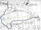
Ballyshannon at the Crossroads It is not often that an entire community has a chance to rectify the mistakes of preceding generations. Ballyshannon, a town which did not have a choice in the planning of its future before the construction of the Erne hydro-electric scheme in the 1940s, now has the opportunity to demand that its inhabitants be consulted before another major environmental disaster, almost seventy years later, becomes a fait accompli. The destruction of a major salmon fishery, the loss of a scenic river, the unnecessary demolition of a national heritage, namely the Falls of Assaroe, and the decades-long adverse economic consequences, can be partially offset by the present generation if it unites in support of a well prepared plan to create what in effect will be a new River Erne tributary, designed to restore a natural water course for the annual salmon migrations, and providing the means for a totally new Falls of Assaroe, all of which are environmentally friendly and economically beneficial. To help achieve the purposes briefly outlined in the preceding paragraph, one overriding factor will be the unity of the townspeople. And that unity is beginning to emerge in the opposition being vociferously expressed to a highway project that would hurt Ballyshannon for many more decades to come, if allowed to be implemented. Ballyshannon has suffered more than most towns of its size at the hands of planners far removed from its daily life, its friendly culture, its historical significance. Following the three-year prosperity during construction of the Erne Scheme, it was allowed to sink slowly into economic decline, even to the extent that it was labelled "the town that Ireland forgot". Its two railway systems were abandoned, its fishery neglected, its young were once more forced to emigrate. Its dried up river bed became an eyesore. Only recently has the ESB begun a belated and inadequate attempt "to beautify" the scars it itself created. What is the remedy? Planners in far away places propose a by-pass road. In actuality, what they propose is a through-pass road, one that ignores the concerns of the townspeople who point out that, instead of by-passing the town, it cuts right through population centres, severing them in two. What is required in similar instances is a feasible alternative. Saying no is not enough. Dispute resolution requires the study of alternatives, and in this case "Vindicator.ca" is privileged to place both plans before a concerned public in graphic form as shown in the maps below. The first was prepared by Donegal County Council and shows the route of the proposed by-pass/through-pass. This map shows the route of the proposed road.
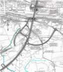
Click for larger image The second map above captures the essence of the alternative proposal. There is one major difference. Where the first map shows the proposed by-pass road being driven over the bed of the Erne, the second shows a new tributary entering the tailrace at the exact same spot, "which is the perfect site to reconstruct a natural waterfall similar in height to the Falls of Assaroe." Whence comes the sources of this new tributary? From the pent up waters of the Erne itself, portion of which initially seeped into Lough Bracken even during construction of the Erne Scheme, which Cementation endeavoured to plug by pumping cement into numerous limestone fissures. There is a pump house presently at the site. From Lough Bracken a connecting channel will link with Sminver Stream and thence into the tailrace. To those of us from an earlier generation of townsfolk Sminver Stream was known as Neely’s Brook. The foregoing encapsulates in lay terms what is at stake. For Ballyshannon the choice is clear—a by-pass/through-pass road splitting the town, with social, economic, health and environmental impacts, or the rehabilitation of the River which the town once was famous, and from which it benefited not merely for decades but for thousands of years. The re-routing of the proposed by-pass/through-pass road is an imperative. So too is unity of support for the new Erne and the new Assaroe. Ballyshannon is at a crossroads in its history. Let its people be guided by that history and the knowledge of what they have already lost. "When one considers that half a century ago a 1,500 yard long tailrace was blasted to 30 feet below bedrock, then to excavate a connecting channel to link Lough Bracken with the natural drainage channel and continue the flow of water downstream makes good ecological sense."The above quotation is taken from a letter written by Paul M. Rohleder of The Mall, Ballyshannon, in March of this year, outlining the alternative plan. That plan needs the backing of environmentalists worldwide.
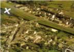
The white X on this aerial view of Ballyshannon marks the spot where the Sminver Stream, otherwise known as Neely's Brook, emerges froma pair of culverts and falls into the tailrace. The publication of this article happily coincides with the launch of a newly designed website linking Canada and Ireland. Mr. Rohleder has extensive knowledge of river rehabilitation in Canada, particularly in British Columbia, one of its most beautiful provinces.
Home | About | Canadian Vindicator | Literature | Gallery | History
|
||||||||||||||||||||||||||||||||||||||||||||||||||||||||||||||||||||||||||||||||||||