
|
|
A Picture with Meaning
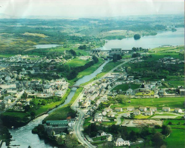 Regular readers visiting this site will be aware that many items now in the Irish section have dealt with one town in Donegal, its history, geology, topography, economy, the fate of its once world famed fishery, rehabilitation of its natural river environment, and its potential to attract tourism revenue far in excess of current earnings. Now for the benefit of those who have not yet been able to visit in person but have expressed an interest in doing so, this first issue in 2002 carries an aerial photograph of Ballyshannon, (courtesy Camera World, Ballyshannon), that complements the word pictures previously drawn in many of the items. The all-invasive impact of the E.S.B hydro-electric dam at Cathleen's Falls, a short distance above the town, can easily be traced along the route of the tailrace. Where once a broad river ran freely, there is already one by-pass road on the dried up river bed, with a second by-pass threatened, its sole purpose being to draw vehicular traffic away from Ballyshannon for the benefit of commerce in other towns. If allowed to proceed along the proposed route, the second by-pass presents as much potential for future harm as did the once heralded hydro-electric project of fifty years ago. A letter sent by A/Deputy County Engineer James Boyle to Patricia McKenna, Member of the European Parliament, on November 7th last year, confirmed that the proposed by-pass "will have the effect of taking 60% of the traffic out of the town centre." The letter further claimed that "the rehabilitation of the river Erne will actually be helped….and (it) will facilitate the development of a riverside walk on each side of the Erne." How the river Erne will be rehabilitated by pedestrian walkways is beyond comprehension. Only if salmon could walk! And pigs fly! Home | About | Canadian Vindicator | Literature | Gallery | History
|
||||||||||||||||||||||||||||||||||||||||||||||||||||||||||||||||||||||||||||||||||||